28 January 2020
Get the app and improve the map
Get the app and improve the map
28 January 2019
A national RR&D4P program mapping the location and extent of all commercial citrus orchards in Australia is set to deliver more accurate yield forecasting across all scales – at national, regional and farm levels.
A partnership between the Citrus Australia, Hort Innovation, the University of New England (UNE), Central Queensland University, Tie-up Farming, government and other industries – the project is a first for the citrus industry. The map will be a baseline for all commercial (> 1 hectare) orchards in Australia.
The development of the map builds on the success of the Phase 1: Multi-scale Monitoring Tools for Managing Australian Tree Crops, Industry meets Innovation project, where one of the major outputs included the first national map of all commercial avocado, macadamia and mango orchards.
Since its launch in September 2017, the map has been viewed over 7800 times and was successfully applied in the response to recent bushfire crisis in Australia.
The ‘Australian Tree Crop Rapid Response Map’ [https://goo.gl/rnqadK] (published in 2017) is being updated at a larger scale (1 hectare) and importantly will include citrus orchards.
Craig Shephard, Senior Researcher, Applied Agricultural Remote Sensing Centre, at the University of New England, said the potential applications for the map were not limited to post-natural disaster monitoring.
“Knowing the distribution and extent of orchards has the power to greatly inform decision-making at farm and industry level,” he said.
“Applications include increased biosecurity preparedness, where targeted field surveys and the implementation of exclusion zones can immediately be implemented following an incursion, saving both time and money.
“For the industry, knowing the spatial distribution of orchards greatly assists with a better understanding of demographics (i.e. regional forecasting), whilst a more accurate measure of production area can assist with improved estimation of annual production and subsequent forward selling decisions.”
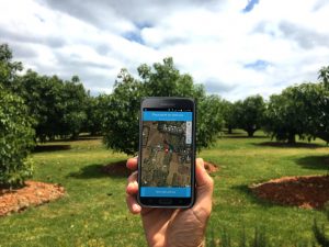
The success of the baseline mapping was in the collaboration between growers and stakeholders, whose contributions via of the Land Use Survey App provided the vital information to map the orchards accurately.
Using the Land Use Survey App (www.qld.gov.au/landusesurvey) anyone can submit a land use observation (from any device, mobile or desktop—it runs in a browser)—particularly for mapping new orchards. The observations submitted will help update vital layer for the industry. Or as Craig says: “Get the app and improve the map!”
He said the mapping adheres to national standards for commodity level land use mapping, supported by the Australian Collaborative Land Use and Management Program (ACLUMP).
ACLUMP promotes nationally consistent land use information. Privacy concerns are acknowledged and respected as the information sources used to compile land use include remotely sensed data (imagery), state and national ancillary datasets, field observation and expert opinion.
No personal or confidential information is collected as part of the land use mapping process nor contained within the land use datasets.
This project aligns with a pilot study that is evaluating a range of remote sensing platforms (satellite, fixed-wing and helicopter) and analytics—including machine learning to determine their accuracies in mapping high risk plant biosecurity hosts in urban and peri-urban areas.
The project is funded by Federal Department of Agriculture and Horticulture Innovation, is led by UNE Applied Agricultural Remote Sensing Centre and features a range of collaborators including: Consilium Technologies, AirborneLogic, ArborCarbon and the NTDPI.
For more information, contact Craig Shephard via email cshepha2@une.edu.au or visit www.une.edu.au/aarsc
Membership
You are not logged in
If you are not already a member, please show your support and join Citrus Australia today. Collectively we can make big things happen.